The European Remote Sensing 2 (ERS-2) satellite, weighting over 5000 pounds was spotted falling uncontrollably as it made it’s course through the atmosphere. It is estimated to reenter Earth’s atmosphere at 11:14 GMT on Wednesday, February 21.
What is the ERS-2 Satellite?
Return to Home: Watch out as this massive satellite, weighing over 5000 pounds, plummets back to Earth. This article delves into the imminent dangers posed by the satellite’s return and highlights the potential implications for our planet. With a formal tone, we explore the significance of this event and the precautions that need to be taken to ensure the safety of individuals and infrastructure.
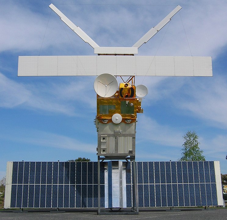
European Remote Sensing 2, was a groundbreaking Earth observation satellite launched by the European Space Agency (ESA) on 21 April 1995, becoming the most advanced Earth observation satellite of its time. It was the second in a pair of satellites designed to observe Earth’s land surfaces, oceans, and polar caps. ERS-2 was largely identical to its predecessor, ERS-1, but featured additional instruments, including a sensor for atmospheric ozone research.
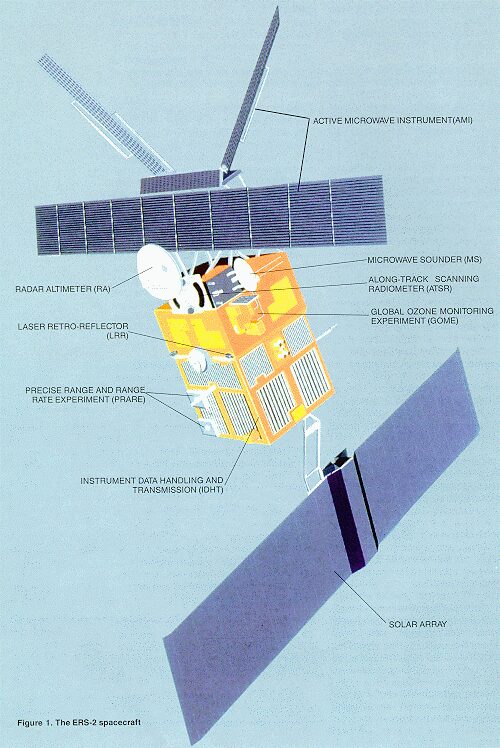
The satellite was equipped with a Synthetic Aperture Radar (SAR), a Radar Altimeter, and a suite of passive instruments measuring ozone content, sea surface temperatures, and winds. ERS-2’s data helped scientists better understand climate change and environmental processes.
Mission
The primary missions of the satellite included:
- Earth Observation: ERS-2 was equipped with a variety of instruments to observe and monitor the Earth’s surface, oceans, and atmosphere. It provided data on various environmental parameters, such as sea surface temperature, ocean wind speed and direction, atmospheric temperature and humidity, land use and vegetation cover, and ice extent and thickness.
- Climate Monitoring: ERS-2 played a crucial role in monitoring climate change by providing long-term data on various climate-related variables, such as sea level rise, changes in polar ice caps, and global temperature patterns.
- Weather Forecasting: The satellite’s instruments contributed to weather forecasting by providing real-time data on atmospheric conditions, ocean surface dynamics, and other relevant parameters.
- Disaster Management: ERS-2 data were used in disaster management efforts, such as monitoring and assessing the impacts of natural disasters like floods, wildfires, and earthquakes.
- Scientific Research: Scientists utilized ERS-2 data for a wide range of scientific research applications, including studies on oceanography, meteorology, climatology, geology, and ecology.
Accomplishments
The ERS-2 satellite achieved numerous milestones and advancements in Earth observation, including:
- Continuing the ERS program’s tradition of observing Earth for nearly 20 years, from 1991 to 2011.
- Providing enhanced imagery and data on land, oceans, and atmospheric features, such as sea ice, geology, forests, waves, bathymetry, and weather events.
- Developing a tandem mission with ERS-1, increasing the number of measurement points for radar altimeters and creating an accurate, three-dimensional digital map of Earth’s land surfaces.
- Including a new instrument called GOME (Global Ozone Monitoring Experiment) to measure atmospheric ozone levels.
- Exceeding its expected life span of three years, operating successfully for 16 years.
- Serving as a foundation for future Earth observation missions, such as the Copernicus Sentinel-1 mission and the Cryosat Earth Explorer mission.
- Collecting extensive data that transformed scientists’ understanding of climate change and environmental processes.
- Supporting the monitoring of natural disasters, such as floods and earthquakes.
- Establishing itself as a key contributor to the International Laser Ranging Service (ILRS).
Discontinuation
After completing its nominal mission duration of three years, ERS-2 continued to operate successfully for another eight years. Despite numerous challenges, including the loss of gyroscopic controls in 2001 and a failure of the onboard data recording system in 2002, ERS-2 remained functional until 2011.
After completing its operational life in 2011, it began a passive reentry phase. To ensure safety and prevent space debris accumulation, ESA performed a series of 66 deorbiting maneuvers between July and August 2011, exhausting the satellite’s fuel and reducing its altitude
Following these actions, ERS-2 was passivated in September 2011, rendering its batteries and pressurized systems harmless
Re-entry
The satellite is set to re-enter Earth’s atmosphere in February 2024, undergoing a ‘natural’ re-entry as it is no longer possible to control its orbit. The reentry is a result of the satellite’s orbital decay, which has been mainly driven by atmospheric drag and unpredictable solar activity.
An international network of partners tracks ERS-2’s reentry, including the Inter-Agency Space Debris Coordination Committee (IADC), the German Aerospace Center (DLR), and the European Union Space Surveillance and Tracking (EU SST). Regular updates on ERS-2’s reentry progress are available on ESA’s Space Debris Office website.
Risks associated with the re-entry
The satellite is expected to break up into fragments around 80 km above Earth’s surface, with the vast majority of these fragments burning up in the atmosphere. However, some fragments could reach Earth’s surface, where they will most likely fall into the ocean. None of these fragments will contain any toxic or radioactive substances
Legacy
The legacy of the European Remote Sensing Satellite 2 (ERS-2) is very remarkable.
Its extensive archive of data, spanning over 16 years, remains a gold mine for scientific research, climate monitoring, and environmental management.
Equipped with advanced instruments like the Radar Altimeter-2 (RA-2) and Synthetic Aperture Radar (SAR), ERS-2 set new standards in measuring sea surface height and imaging Earth’s surface with unprecedented accuracy.
ERS-2’s contributions to climate monitoring have been instrumental, furnishing policymakers with essential data for understanding climate change impacts and formulating evidence-based policies. Furthermore, its role in international collaboration and capacity-building initiatives has empowered global communities to leverage satellite-based environmental monitoring for disaster response and sustainable development efforts.
This enduring legacy continues to inspire innovation in remote sensing technology and scientific research. As a beacon of success in Earth observation, ERS-2 has paved the way for future missions and advancements, driving progress towards a deeper understanding of our planet’s dynamic systems and fostering resilience in the face of environmental challenges.
Get live updates about ERS-2 here
Read more about the upcoming solar eclipse here